Some insight into the life of Thomas Frost
Last week, I began planning the first full episode of the Washington, Our Home, video series and I decided the creation and exploration of the Willamette Meridian would be a good first start. To begin with, as I asked in a previous blog post, I had to learn why in the world someone in the mid-1800’s would decide that a straight line north and south from Portland, Oregon, was even necessary.
As it turns out, there are a lot of things that we take for granted every day that are based on that question. Why are all the other towns and cities in Washington located where they are? How were city limits designated? Ever hear of an “unincorporated area” of a certain county? Why do cities have to annex property from counties to add it to it’s tax rolls? All of these questions can be answered by looking deeper in to the reason for meridians.
 Without going into too much detail (and ruining the future video episode), I’ll just explain it like I did to my wife this afternoon. Imagine back before Washington was even a territory…back before it was even Oregon Territory. Prior to 1800, when all that was known of the land we live on today was that it was west of civilization. It took great men like George Vancouver, Charles Wilkes, Juan Francisco de la Bodega y Quadra, Robert Gray, and others to forgo their comfortable lives and go someplace that no one had ever been before. During their time here, they drew maps…crude as they were…but they were the first to chart the expanse that was the American west, until Meriwether Lewis and William Clark reached its end at the Pacific Ocean.
Fast forward fifty years, and you’ll find settlers streaming into the area along the only known road…the Oregon Trail. These pioneers would continue west until they found a spot of land that suited them and they would claim a certain amount for themselves. Known as “homesteaders,” these pioneers were isolated from their fellow man on the land they were trying to take. Singularly, they were sitting ducks for thing like harsh winters, Indian attacks, natural disasters, starvation, disease, and any number of other life-threatening maladies. Eventually, someone realized that there was much more safety in numbers. Perhaps if homesteaders were gathered together in municipalities, they’d have a better chance of survival. It took the sheer will of the American pioneer to discover the undiscovered, but it took the fledgling American government to bring order to the chaos that was the western frontier.
 Enter the General Land Office, the precursor to today’s Bureau of Land Management. This office began undertaking the immense mission of parceling out the newly explored country. It was determined by the GLO leaders in Washington D.C. that townships in the new territory were to begin in areas six-miles square by six-miles square. But they had to start somewhere. Before the Washington Territory was cut out of the Oregon Territory, the GLO had sent out highly specialized teams of surveyor/soldiers who established the Willamette Meridian as the principal meridian of the territory. Essentially what that meant is that (as you can see on this map) a line was drawn north and south – called a “meridian” – and another line east and west – called a “baseline,” and six-mile squares were then extended from the center where the two lines intersect.
The creation of the meridian and subsequent surveys divided the virgin country into the six mile by six mile sections. It was determined that this was the appropriate size of burgeoning townships, and city limits were originally set as such. This system is the reason why our local county, city and town borders are the way they are. Look at a Google map of the state and you’ll find square after square of trees or fields or towns or parks, all of which are attributable to the system put in place by the GLO.
If you think about it, it does make sense. After all, who could better repel an Indian attack…a family of seven by themselves, or a town of 200 with a clear system of leadership? Once the country had been divided, settlers began clustering themselves around pre-determined townships that had been platted for strategic military or geographical reasons.
After Washington officially split from Oregon, the first surveyor general of the new Washington Territory arrived in 1854. Shortly after his much delayed arrival in Olympia in March of 1855, James Tilton struck upon a novel idea. It was the responsibility of most surveyor generals to adopt a principal meridian for the survey of their territories, and since the Oregon-based Willamette Meridian inconveniently ran into the waters of Puget Sound, Tilton decided to establish a new principal meridian for all future surveys of the Washington Territory. This became known as the Puget Sound Meridian. Tilton wrote to his supervisors in Washington D.C. to inform them of his intention.
Surveyor General Tilton had awarded his GLO survey contract #3 to Thomas A. Frost, with the following instructions:
“You will commence at the northeast corner of Township 20 North, Range 1 East, Willamette Meridian and run due East 24 miles upon the 5th Standard Parallel north of base line. Upon arriving at termination of 24th mile, commence ‘Puget Sound Meridian,’ marking the point of starting the new Meridian by erecting a prominent and distinguishing monument.”
The initial point of the Puget Sound Meridian began near the Muckleshoot Prairie. But this new principal meridian for the survey of the public lands in the Washington Territory would prove to be very short lived. Upon learning of Frost’s survey activities along the Puget Sound Meridian, the acting commissioner of the GLO in Washington D.C. sent an urgent letter to Surveyor General Tilton that in effect immediately invalidated the Puget Sound Meridian and further, gave him instructions on how to correct it. But it wasn’t until the summer of 1857 that the marks on the posts and bearing trees were corrected, although it wasn’t for a lack of trying. In a letter to the GLO Commissioner, Tilton stated:
“An attempt was made by this office to obey the instructions during the autumn of 1855, but the examiner of surveys was driven in by the hostile savages inhabiting the region traversed by the Guide Meridian, and it has not been safe or practical for any white man, except in armed parties to penetrate the country in that direction until this summer.”
In August of 1857, Tilton ordered Deputy Surveyor Edward Gibson to traverse the Puget Sound Meridian for its extent of 48 miles north and destroy the survey marks made by Thomas Frost in 1855. It took Gibson 26 days to walk – under constant threat of Indian attack – the 96-mile round trip that Frost had made two years earlier.
 So why hadn’t Deputy Surveyor Thomas Frost gone back and made the necessary corrections to his own work?
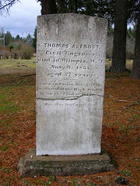
Born on December 2, 1828 in Boston, Massachusetts, had been employed as a railroad engineer in Massachusetts, Vermont and Indiana before coming to Olympia with Surveyor General Tilton. Frost died of typhoid fever on November 9, 1855, just months after completing Washington’s own, albeit short-lived principal meridian.
He was just 27, and is buried at Union Pioneer Cemetery in Tumwater where I visited today after church.
-
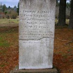
- The headstone of Thomas Frost
-
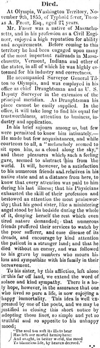
- The obituary for Thomas A. Frost
-
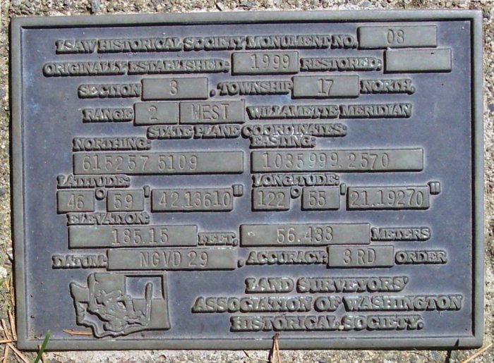
- The 2nd of 2 gravesite plaques
-
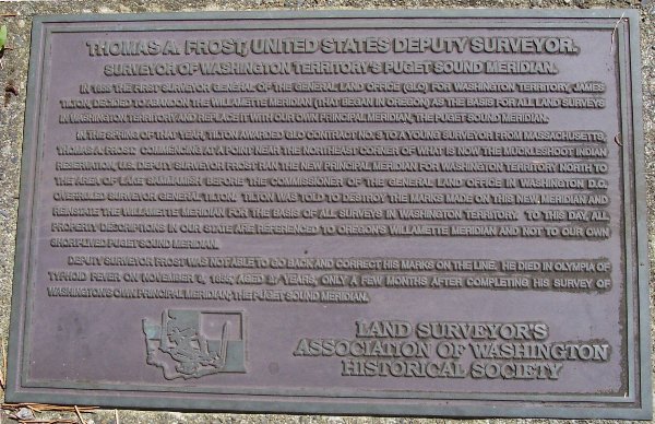
- The 1st of 2 gravesite plaques
Thanks Pat! Sounds like you and I have a few things in common…how can I get involved in more of these Washington State historical and cultural areas?
The Land Surveyor’s Association of Washington Historical Society placed the bronze plaques to honor Mr. Frost. Our local chapter of LSAW also did the Fort Eaton site you previously mentioned.
Pat Beehler