In search of Medicine Creek Treaty Tree, Part 1
Back in June of 2016, a colleague of mine at the Washington State Archives – Olympia branch archivist Benjamin Helle – published an article in that agency’s newsletter about a little-known and seldom-visited monument in the South Sound area dedicated to the Medicine Creek Treaty. What followed was an adventure in state history that nearly anyone can undertake.
All Washington residents should be at least vaguely familiar with the Medicine Creek Treaty, an agreement signed in 1854 by then-territorial governor Isaac Stevens and a number of Native tribal leaders, foremost of whom was Chief Leschi of the Nisqually Tribe. Stevens’ job as territorial governor and superintendent of Indian affairs was to keep the peace and secure tribal lands for future settlement. While he accomplished the latter, it also led directly to his failure to accomplish the former.
The Medicine Creek Treaty promised the tribes compensation for their territory but resulted instead in the forfeiture of prime farmland and the relocation of the tribes onto reservations. When Chief Leschi and his followers protested in Olympia, Governor Stevens declared martial law. A series of further skirmishes resulted in several deaths, and the Puget Sound War ignited the region in 1855. You can read more about that in some of my previous posts.
As a student of Washington State history, it is fascinating to watch scholars and amateurs alike try to piece together the past in an effort to reach the most accurate version of events. Many of those efforts over the years have resulted in monuments, plaques, memorials, and even a posthumous retrial in 2004 of Leschi himself (where he was exonerated of the alleged crimes for which he was hanged in 1858).
As with numerous other Washington tales, I find it impossible to simply take a snapshot and write about it. On the contrary, researching most of my article topics only leads deeper into more remarkable and previously unknown (at least to me) information. Soon, I find myself lost in yet another rabbit hole only to come out on the other side intrigued and wanting to know more.
The Medicine Creek Treaty story is no exception.

Timberline students building their memorial in 1976. WSDOT Collections, WA State Archives.
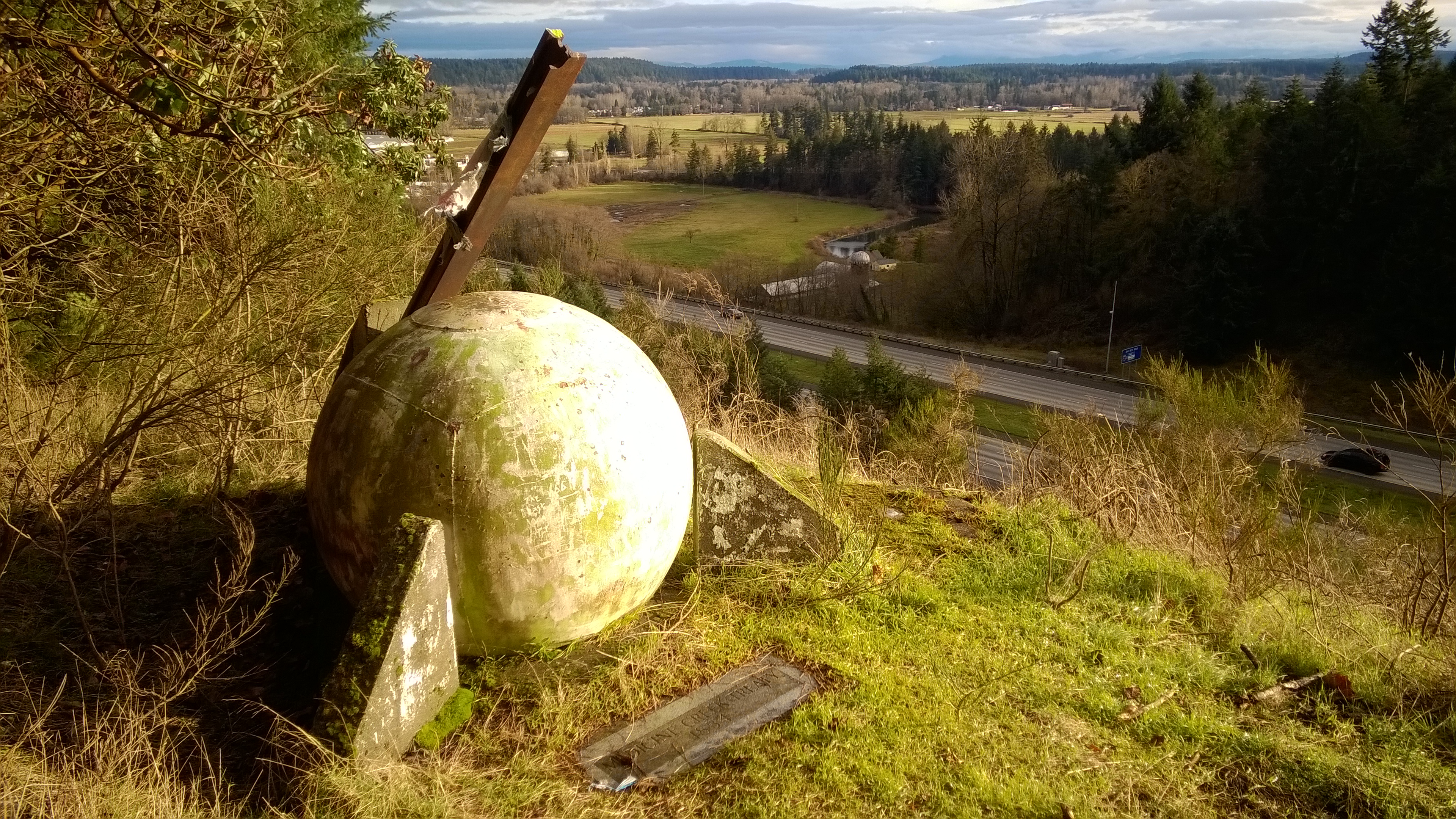
Ben’s article about the Medicine Creek Treaty Memorial contained black and white pictures that showed students from Timberline High School’s Indian Studies class building their time-capsule monument high on a bluff overlooking the Nisqually River delta in 1976. The concrete and steel sphere was constructed near the site of the original grove of trees beneath which Isaac Stevens and others signed the Medicine Creek Treaty. The last of those Douglas firs left standing was subsequently given the name “Treaty Tree.” But by 1976, Treaty Tree had begun dying – likely due in part to the construction of Interstate 90 Interstate 5 (thanks, Barbara!) in close proximity. It was officially declared dead in 1979 and blew down in a windstorm in 2007.
In studying the picture, it was easy to surmise that the angle from which it was taken could have been from one of only two directions since the image shows the freeway across the delta, now known as the Billy Frank Jr. Nisqually National Wildlife Refuge. Using Google Earth and my own knowledge of the area, I quickly guessed where the monument resided. The following day, I was thrilled to spot for the first time something I had driven past hundreds of times before. There, on the northwestern hillside coming up out of the watershed, at the end of a long row of towering trees nearly obscuring it from sight as traffic raced by at 65 miles-per-hour, was the round monument I had been seeking.
Even if one was looking for it in its exact location, it could be lost in the blink of an eye at freeway speeds or in poor weather. On more than one occasion since, I have noticed it completely enveloped by fog early in the morning. And I also noticed that there was no clear path to reach it…at least not from the freeway. It would have been dangerous to try anyway, so the next option was to approach it from surface streets. After a few trials and errors, I succeeded in finding a road that came close to where the monument lay.
Crossing a vacant field and hiking a short way through the woods (likely on private property, by the way), the trail gave way to a clear ridge overlooking the freeway several hundred yards below. And to my left, clearly visible, was the orb I had been seeking.
As a side note, I have to confess that moments like this are what drive me to continue exploring the mysteries of our great state. That monument has existed for 40 years, and the cause for its inception is well over 160 years old. Hundreds of people no doubt knew about it and dozens of those probably helped create it. But finding these things on my own gives me a sense of discovery and accomplishment that I like to think comes from the very same internal well from which Lewis and Clark must have drawn their inspiration. I get butterflies in my stomach and, more often than not, immediately wish I had brought someone else with me to share the experience.

The Medicine Creek Treaty Tree monument’s isolated location is both a blessing and a curse. While the structure remains entirely intact, it is unfortunately also adorned with graffiti, overgrown shrubbery, moss, and trash. A sun-bleached and tattered American flag clung perilously to the tip of the steel beam and the grounds around it were littered with empty beer cans and liquor bottles. However, its appearance didn’t seem to dampen my spirit as I began to take pictures to document my visit (which can be seen here).
The strange shape of the monument is apparently supposed to resemble a peace symbol when viewed from above (almost as if the students in 1976 had foreseen the future common use of satellite maps). According to Helle’s article,
“The spherical form of the monument attempts to symbolize the Indian’s view of the circular nature of life and their culture. The straight steel beam symbolizes white society – a linear, industrial society. The two elements are juxtaposed evenly, one against the other; together, yet with the integrity of each standing separately.”
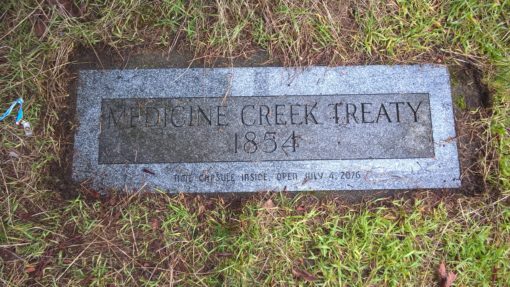
“The sphere itself was hollow, and contained a ‘time chamber’ filled with material relevant to the purpose of the project to be opened in 2176. It included a copy of the 1854 treaty, copies of Lacey and Olympia newspapers, names of all students and faculty administrators involved, typical ‘artifacts’ common to 1976, messages from officials to the future, and a letter to the future Timberline students of July 4, 2176. [sic]” (The actual date on the marker itself is 2076, not 2176).
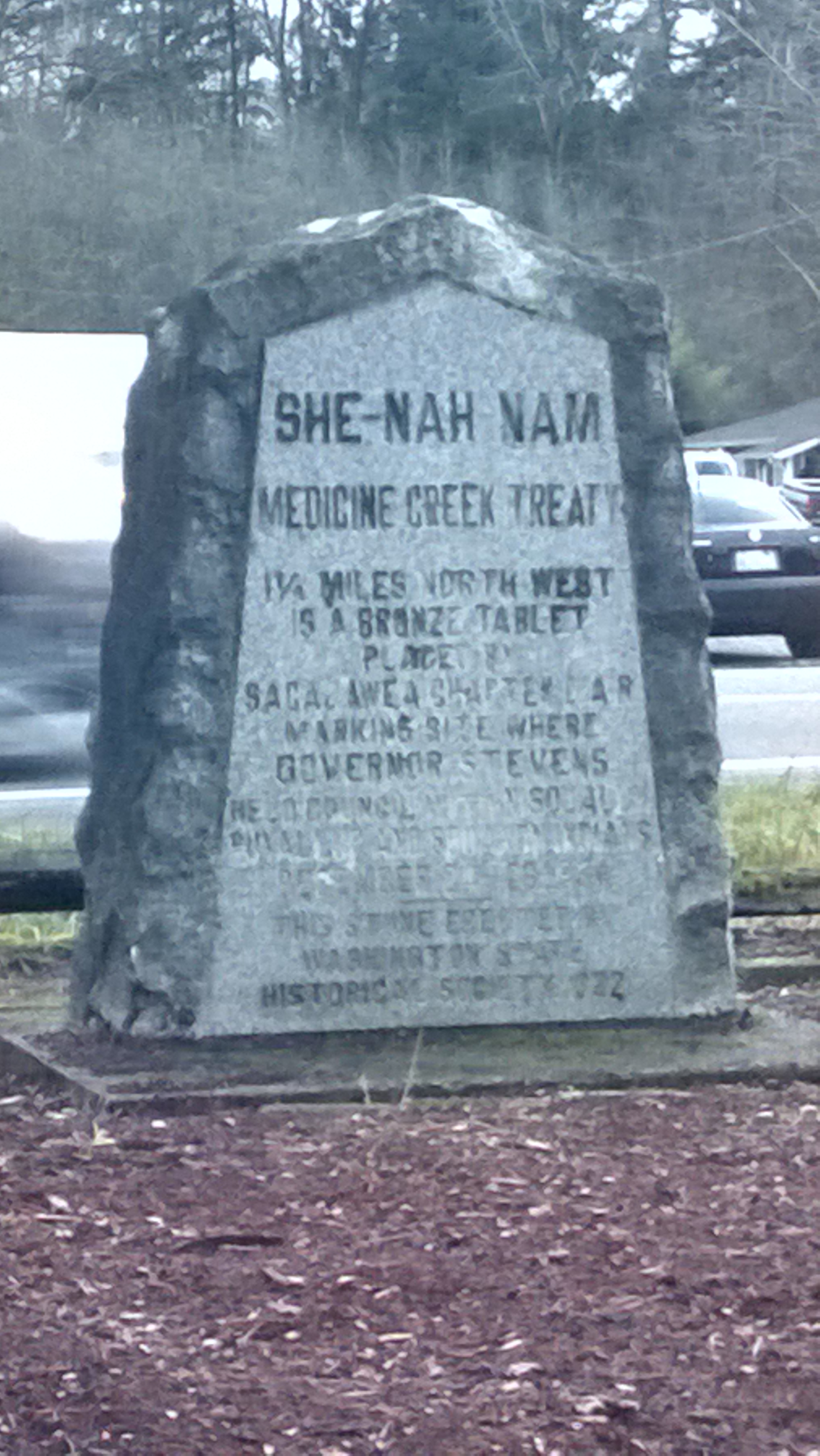 Though I will be 101 years of age in 2076, I hope I am still around to witness the capsule’s opening. In the meantime, my discovery of this structure has prompted a number of other questions which warrant further exploration on my part. To begin with, several years ago I “discovered” another monument at a gas station near the Nisqually reservation indicating it was a mile and a quarter from a bronze tablet where Treaty Tree once stood. Since the Timberline sphere has no bronze and is 1.64 miles from the 1922 Nisqually Valley Grocery marker, where is the bronze tablet? And if neither of these monuments are near the actual site where the treaty was signed, where is the actual location of Treaty Tree? This photo gives us a clue…
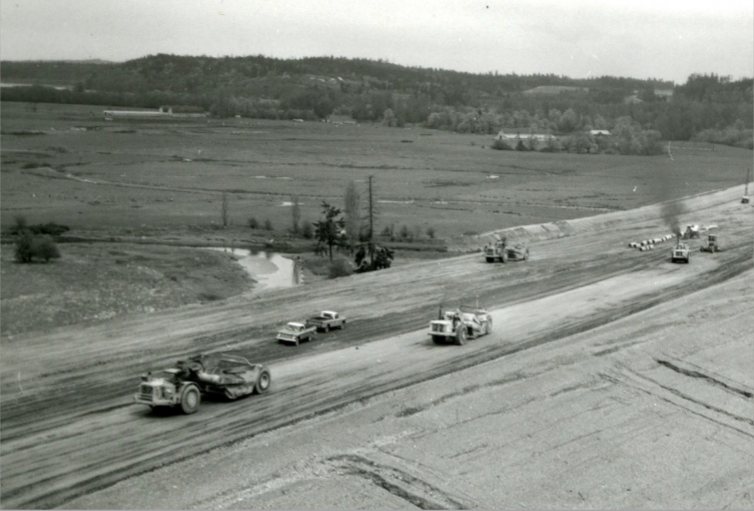
The Department of Highways was careful to avoid the Treaty Tree, center, when it constructed I-5 through the area in the 1960s, but fill placed in the right of way likely affected its health.
WSDOT Photograph Collections, WA State Archives.
You bet! This is exactly the reason why I do what I do…to educate and entertain! Thanks for reading. 🙂
My brother and I always spotted this object as kids riding in the car from Portland to Federal Way. We called it “The Cannon” based on its briefly glimpsed shape. Over the years I have often wondered just what “that thing” is up there, even scoping out Google Maps to see if there was a way to access it… Finally the mystery is solved! The history and significance is fascinating too. Thanks so much for this!
I was recently researching what was known about the Medicine Creek Treaty Tree and found an article by Mike Layton, in the Olympian, May 16, 1965. The title is “A Doomed fir tree Broods over History.” The article includes a picture of the dying fir tree, described as out in the middle of a cow pasture. For me, one of the messages was that the construction of I-5 probably had little influence on the demise of the Treaty Tree. It may have hastened the tree’s death, I suppose, but it’s pretty clear that the tree was in really bad shape years before I-5 was built through the Nisqually Bottom.
Ah, if only there were a trail! Seriously, it’s like they purposefully made it hard to reach. I had to drive out to the closest location I could find and hike the rest of the way to the monument. There’s no trail, but if you punch through the woods a bit you come out on the other side by the freeway and can walk along the top of the slope until you reach the monument. Just be careful not to trespass on private property, as several homes are located along the top of that ridge as well. Good luck!
How do you get to the trail leading to the monument?
Well, THAT’S a huge oversight! Thanks for setting me straight. And fortunately for the both of us, history never dies!
Dear Erich, I would like to suggest a correction to this. In the paragraph that starts “Ben’s article about the Medicine Creek Treaty…” you write that the monument may have been lost due to the construction of Interstate 90. I’m rather sure that you meant to say Interstate 5. Unless, of course, I-90 has been relocated 30 plus miles southwest of its original location. Thanks for keeping Washington State history alive.
Assisted by a friend, I worked for several years looking for the bronze plaque (which had been on the Treaty Tree) mentioned on the She-Nah-Nam stone marker pictured above. It disappeared during the 1970’s, reportedly during freeway construction. We looked for it by phoning and bugging various historical groups/museums over time, trying to pick people’s brains. Finally, in 2017, we were rewarded when the WA State Historical Society found it. Previously they had said they THOUGHT they had it but needed to search. It is now documented in their collection and we ‘visited’ it just to make sure!
http://www.washingtonhistory.org/collections/item.aspx?irn=28129&record=2